By Meteorologist Mike Skurko
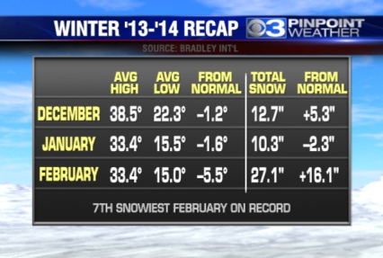
It’s hard to believe it given the threat of snow tomorrow and the persistent cold next week, but today is March 1st and the first day of meteorological spring (which is slightly different from astronomical spring, which starts on the spring equinox). Whenever the cold and snow does finally stop, most residents of western Massachusetts will look back on this as a cold and snowy winter we had to endure.
Snowfall totals through the end of February have topped out at 50.1 inches of snow, which is already 9.6 inches above an entire normal winter. Despite some impressive snowstorms hitting the Northeast this winter, the Pioneer Valley did not set any new snowfall records [so far] in 2013-2014. February ranked 7th all-time for the snowiest February on record.
Temperatures also finished below average this winter, but not quite the record cold that people may expect. Other parts of the country certainly did set some record cold temperatures during our visits from the “polar vortex.” While western Massachusetts had some frigid days, it didn’t translate into record cold. Only one record low was set this meteorological winter on January 4 with a low of -9 (previous record was -7 in 1981).

Leave a comment