NOAA updates Atlantic hurricane season forecast

August 9, 2014 - Leave a Response

By Meteorologist Mike Skurko

With the peak of Atlantic hurricane season nearly here, NOAA forecasters have increased the likelihood of a below-normal season.

“We are more confident that a below-normal season will occur because atmospheric and oceanic conditions that suppress cyclone formation have developed and will persist through the season.” said Gerry Bell, Ph.D., lead seasonal hurricane forecaster at NOAA’s Climate Prediction Center, a division of the National Weather Service.

In their initial outlook in May, NOAA predicted a 50 percent chance of a below-normal season, a 40 percent chance of a normal season, and a 10 percent chance of an above normal season.  Those numbers are now 70 percent, 25 percent and 5 percent, respectively.

The chart below shows their new numbers predicted for the Atlantic hurricane season.  The new range of numbers shows one less named storm, and the possibility of no major hurricanes at all:

Facebook_Screencap

The initial factors relating to a below-normal hurricane season can be found in our CBS3 Pinpoint Weather Blog entry from May.

The entire press release from NOAA can be found here: http://www.noaanews.noaa.gov/stories2014/20140807_hurricaneoutlook_atlantic_update.html

Hawaii bracing for back-to-back hurricanes

August 7, 2014 - Leave a Response

By Meteorologist Mike Skurko

wx blog5

Hurricane Iselle is expected to make landfall late Thursday night on the Big Island of Hawaii.  The category 1 storm is packing winds of 75 mph, and will bring excessive rain and high surf to the islands.  Below is a forecast graphic from the National Weather Service in Honolulu depicting the landfall of the hurricane around 10 p.m. Hawaii Standard Time (4 a.m. Friday for us).  You can see how the eye of the storm will pass right over the big island, with waves above 20 feet expected in advance of the storm.  A wind speed of 54 knots shown below equals 62 mph.

wx blog2

wx blog3

Believe it or not, Hawaii does not frequently see a direct hit form a hurricane.  It does get brushed by storms in the Central Pacific, similar to how New England gets brushed by hurricanes but infrequently sees a direct landfall.  Iselle will be the first hurricane to make a landfall on the Hawaiian Islands since 1992, with only two others directly hitting Hawaii since 1950.

That makes the next point even more unbelievable … another hurricane, Julio, is on the heels of Iselle and has Hawaii in its path.  While it did strengthen to a Category 2 hurricane earlier today, it is expected to weaken this weekend.

Meteorology 101: cold pool aloft

August 6, 2014 - Leave a Response

By Meteorologist Mike Skurko

You here this expression a lot in weather forecasts – “cold pool aloft.”  What exactly does that mean? Why is it commonly attributed to afternoon cloud development and a chance of rain showers?

A cold pool aloft is exactly as it sounds … it’s a cooler-than-normal pocket of air in the higher levels of the atmosphere.  Frequently, these cold pools are assessed at about 10,000 to 20,000 feet.  It doesn’t create a chilling effect at the surface for us, many times not having a significant impact on the day’s temperatures.  But it does aid in cloud and thunderstorm development higher up in the atmosphere.

As a parcel of air at the surface warms up during the day, it wants to rise.  This is because warmer air is less dense/more buoyant than the cooler air around it.  As it rises, the parcel of air cools off as well according to laws of thermodynamics.  Eventually, it finds an equilibrium in the atmosphere.

However, when a “cold pool aloft” exists, the parcel that began rising from the surface wants to continue rising through the cold pool.  Even though the parcel was cooling as it rises, it still remains relatively warmer than the cold pool and wants to continue its upward journey.

With these air parcels being allowed to continue rising, it induces more cloud development and rain/thunderstorm potential.  This is why cold pools aloft are often described as an unstable atmosphere.

Tropical Storm Bertha innocently passes by

August 5, 2014 - Leave a Response

By Meteorologist Mike Skurko

A disorganized and quickly weakening Tropical Storm Bertha will make its closest pass by New England on Wednesday, but it will have no effect on the weather around the region.  It was briefly upgraded to category 1 hurricane status (74-82 mph), but was downgraded early Tuesday morning as it passed by the Carolinas.  The orange shaded area inside the yellow line represents the storm’s tropical storm force wind field of at least 39 mph, with maximum winds estimated near 50 mph.

Facebook_Screencap

While the storm has no impacts on the weather, it will impact the surf.  The National Weather Service has issued a Rip Current Statement for ocean-facing beaches along the southern New England Coast.

wx blog5

Massachusetts tornado facts

August 3, 2014 - Leave a Response

By Meteorologist Mike Skurko

After an EF-2 tornado touched down just north of Boston on Monday morning, the National Weather Service compiled a bunch of information regarding tornadoes in Massachusetts.  Monday’s tornado was rare for two reasons – it was the first tornado on record in Suffolk County, and occurred at about 9:30 in the morning.

Here is a bunch of graphics regarding tornado frequency across the state by month, strength, and county:

wx blog

wx blog2

wx blog3

July 2014 recap

August 2, 2014 - Leave a Response

By Meteorologist Mike Skurko

Temperatures were about a degree above average in June, and we continued that pace for this past July.  We also got a little more rain returning to the region over the last month after about a two-inch deficit in June.  Our total precipitation for the year is 1.87 inches above normal.

We had our first official heat wave of the year July 1 – 3, with highs reaching 93, 95, and 91 degrees.  Our total number of 90-degree days this summer is now at ten (Bradley International’s yearly average is 18).

wx blog

EF-2 tornado confirmed in Revere, MA

July 30, 2014 - Leave a Response

By Meteorologist Mike Skurko

wx blog

An EF-2 tornado touched down just north of Boston in the town of Revere, MA on Monday morning.  Estimated wind speeds reached 120 mph.  Fortunately, no injuries were reported despite the unusual time the tornado touched down (9:32 a.m.).  According to the National Weather Service, this is the first tornado in Suffolk County since records began in 1950.

Below is the National Weather Service’s official statement regarding this storm:

Public Information Statement
National Weather Service Taunton, MA
432 PM EDT Mon Jul 28 2014

…Tornado confirmed in Suffolk County MA…

Location…Chelsea and Revere in Suffolk County MA
Date… July 28 2014
Estimated time…9:32 – 9:36 AM EDT
Maximum EF-scale rating…EF2
Estimated maximum wind speed…120 mph
Maximum path width…3/8 of a mile
Path length…2.0 miles
Beginning lat/lon…42.3980 / -71.0219
Ending lat/lon…42.4225 / -71.0037
* fatalities…0
* injuries…0

* The information in this statement is preliminary and subject to change pending final review of the event(s) and publication in NWS storm data.

…Summary…

The National Weather Service in Taunton, MA has confirmed that a tornado touched down on the morning of july 28, 2014 in Chelsea and Revere in Suffolk County, Massachusetts. It had a path length of 2 miles and path width of 3/8 of a mile. Most damage had a rating of EF-1 on the Enhanced Fujita scale but EF-2 damage was observed in the vicinity of Revere Beach Parkway. Thus this event is classified as an EF-2 tornado. Maximum wind gusts were estimated at between 100 and 120 mph. Thankfully and miraculously there were no fatalities or injuries reported as a result of this tornado.

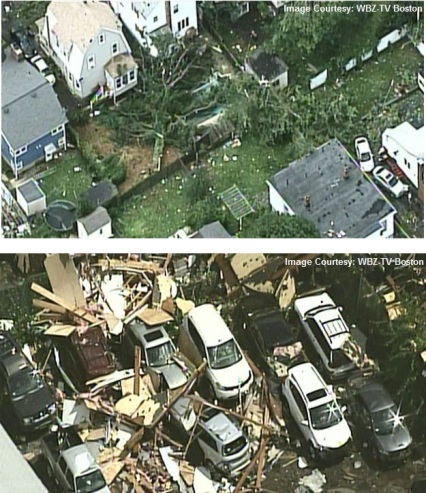
Although the tornado began in Chelsea…where a window was reported to have been blown out on Dudley Street…the overwhelming majority of damage occurred in the town of Revere.

The tornado moved across the Chelsea River…directly across the Paul Cronin Memorial Skating Rink…and portions of its roof were blown northeastward across Route 16. Numerous houses on Revere Beach Parkway were severely impacted…with one roof completely blown off. In that vicinity…large oak trees were snapped mid-way up. Just to the east of the on-ramp from Route 107 to Route 16…trees were downed from west to east. Trees just to the west of Wilson Street were downed from east to west. This gave a clear delineation of the track of the tornado…which is low pressure and has trees blowing in toward the track. Some trees and tree limbs were lifted up and deposited on top of houses immediately behind Revere Beach Parkway.

The damage was widespread throughout much of the center of Revere. The tornado traveled northward…basically following Route 107/Broadway. At the town hall…windows were blown out and there was roof damage. A large birch tree was uprooted there. More than a hundred homes had damage that ranged from siding torn off to portions of roofs lifted or blown off. There were several store signs that were destroyed. Debris from homes could be seen collecting on fences. Trees fell on several cars with a few being crushed.

The police reported that a car had been overturned…to the west of Broadway at the intersection of Malden Street and Carlson
Avenue. The damage path continued northward to just beyond the rotary at Route 60. Near that rotary there was a billboard lying on top of several cars.

The total path length was 2 miles and the path width was approximately 3/8 of a mile…with a sharp cutoff of the damage just east of American Legion Highway/Route 60.

The National Weather Service would like to extend its appreciation to our North Shore and Boston SKYWARN Amateur Radio Coordinators…the Massachusetts Emergency Management Agency Region 1 office…and the Revere Police Department for helping us tremendously with this storm survey.

Cold front creates stormy weather tonight, comfortable weather tomorrow

July 23, 2014 - Leave a Response

By Meteorologist Mike Skurko

A cold front is slicing through the Northeast this evening, allowing the severe thunderstorms to develop out of this hot, humid air mass ahead of it.  The surface map this evening shows a pretty fine line as to where this frontal boundary is  – humid and unsettled ahead of it, comfortable and quiet behind it:

Facebook_Screencap

This front will push through Western Massachusetts overnight, but may stall out for a brief moment just off the coast.  This may allow a decent amount of cloud cover to start off the day, but skies will eventually clear from north to south later in the afternoon.  More importantly, the drier air mass behind the front WILL move in tomorrow.  Check out Futurecast’s depiction of temperatures and dewpoints in Springfield on Thursday – much better than the 90-degree heat we’ve dealt with the last two days:

Facebook Forecast

Sunny skies make it a fantastic pair of days on Friday and Saturday, with humidity continuing to stay low.  Dewpoints across the Northeast stay in the 50s, shown on this model in blue:

wx blog

Severe storms possible Wednesday

July 22, 2014 - Leave a Response

By Meteorologist Mike Skurko

Summertime heat and humidity returned to Western Massachusetts today as high temperatures touched 90 degrees and the heat index climbed into the lower-90s this afternoon.  Fortunately, an area of high pressure is in control this evening and keeping our weather quiet.  This will not be the case tomorrow.  Here is this afternoon’s surface map, click for a larger view:

wx blog

An approaching cold front will be slicing into this hot, humid air mass on Wednesday, providing the trigger needed for some thunderstorms to develop.  (Notice how the dewpoints are high all across the Northeast ahead of the front, indicated by the little green numbers on the map)  The National Weather Service’s Storms Prediction Center in Oklahoma, put Western Massachusetts and northern New England under the slight risk category for severe thunderstorms to develop beginning late tomorrow afternoon.

wx blog

Given that the center of this targeted area seems to be off to the north of Springfield, it is reasonable to assume that the best chance for stronger storms on Wednesday will be areas north of the Mass Pike.  Futurecast is depicting this possible scenario for Franklin County early tomorrow evening.

Facebook_Screencap

However, it should also be noted that the entire viewing area could see a thunderstorm tomorrow.  Below is another raw computer model run (18Z NAM) that shows thunderstorm development from Maine all the way down into Maryland.  The Storms Prediction Center has cited that the *deep level wind shear needed for severe weather will be much weaker to the south compared to northern New England.  Either way, keep an eye to the sky and watch out for a bumpy ride across Western Massachusetts on Wednesday evening.

wx blog2

*deep level wind shear – wind shear is defined as the change of wind speed and direction with height.  Thunderstorms typically become more organized and persistent as vertical shear increases

NOAA releases detailed 2013 “State of the Climate”

July 19, 2014 - Leave a Response

By Meteorologist Mike Skurko

NOAA released their annual State of the Climate for 2013 on Thursday.  The full report is a collaboration of 425 authors from 57 different countries.  NOAA’s National Climatic Data Center in Asheville, NC served as the lead editors of the report.

NOAA Administrator Kathryn Sullivan, Ph.D. said, “This report provides the foundational information we need to develop tools and services for communities, business, and nations to prepare for, and build resilience to, the impacts of climate change.  These findings reinforce what scientists for decades have observed: that our planet is becoming a warmer place.”

Here is the full 280-page report in .pdf format, while a nice webpage that breaks down some of the temperature, ocean, and greenhouse gas highlights can be found at http://www.climate.gov/news-features/understanding-climate/state-climate-2013-highlights

Below is a few excerpts of some key points outlined by NOAA’s announcement/release this week:

Greenhouse gases continued to climb: Carbon dioxide concentrations increased by 2.8 ppm in 2013.  At the Mauna Loa Observatory in Hawaii, the daily concentration of CO2 exceeded 400 ppm on May 9 for the first time since measurements began at the site in 1958.

wxblog4

Warm temperature trends continued near the Earth’s surface: 2013 was among the warmest years on record, ranking between second and sixth depending upon the data set used.  Australia observed its warmest year on record.

wxblog5

Sea level continued to rise: Global mean sea level continued to rise during 2013, on pace with a trend of about 2.8 to 3.6 mm per year over the past two decades.

The Arctic continued to warm; sea ice extent remained low: The Arctic observed its seventh warmest year since records began in the early 20th century.  Arctic sea ice extent was the sixth lowest since satellite observations began in 1979. All seven lowest sea ice extents on record have occurred in the past seven years.

wxblog6

wxblog7

Tropical cyclones near average overall / Historic Super Typhoon: The number of tropical cyclones during 2013 was slightly above average, with a total of 94 storms, in comparison to the 1981-2010 average of 89. The North Atlantic Basin had its quietest season since 1994.  Super Typhoon Haiyan – the deadliest cyclone of 2013 – had the highest wind speed ever assigned to a tropical cyclone, with one-minute sustained winds estimated to be 196 miles per hour.