By Meteorologist Mike Skurko
This week marks the midpoint of meteorological winter, defined as the full months of December, January, and February. Before winter began, we presented the expected snowfall for western Massachusetts this season in the CBS3 Pinpoint Weather Winter Outlook.
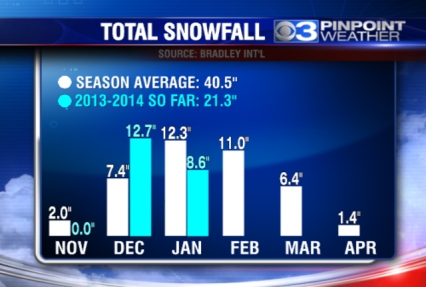
The forecast called for 60 to 70 inches of snow. Using a midpoint of 65 inches, that would be about 60% more than our average winter. Let’s check out how we’re doing so far:
The numbers in white represent an average winter, while the numbers in blue represent the actual snowfall so far this season. The average winter at Bradley Int’l is 40.5 inches of snow, which would calculate to 14.2 inches through today, January 12th. So far, however, we have already received 21.3 inches of snow … exactly 50% above average at this point of winter.
So, we’re not quite at 60% above average, but we are certainly well ahead of the normal pace with snow so far this winter.

Leave a comment