By Meteorologist Mike Skurko
Earlier this week, rumors of another major snowfall for tonight were starting to swirl around western Massachusetts. Clearly that is not going to be the case now. Even in the last 24 to 48 hours the predicted snowfall continues to be less and less with each passing model run.
One explanation for this is that the low pressure center has bumped itself further north over the last several model runs. The 540-line (the “rain/snow” line) has moved northward into our region as a result.
The following 4 images depict the low pressure center and the 540-line (the red dotted line through southern New England) for the last 4 model runs. These are “ensemble mean” models, meaning each image is more or less an average of all the model runs for that time. Each image is for 10 p.m. tonight. The first image was from the 4 p.m. model initialization last night. The second model was run at 10 p.m. last night, the third was from 4 a.m. today, and the final image was from the model run at 10 a.m. this morning.

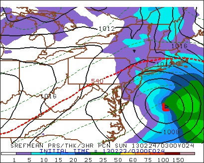


At first glance, all four images may not appear all that different. But take a closer look, and pay particular attention to that 540-line. For the first image (the model run at 4 p.m. yesterday) the 540-line is stretched out across the Interstate 84 corridor through Connecticut. Each successive image inches that line just a little further north, and by the last frame (from the model run this morning) we see the 540-line has pushed itself into the downtown Springfield area.
Also notice how the low pressure system is enlongated just a little bit more to the northwest by the last frame, which is helping budge this 540-line north. It’s subtle, but it’s a huge contributor why we’re expecting a little more rain and a little less snow tonight. If you’ve been watching the radar over the last few hours, you would have also noticed a mix of rain and snow across Hampden county early this evening, rather than an all-out snow.
Overnight we will see this 540-line sag as some colder air wraps in behind this system, which will eventually allow for more places to changeover to snow. However, accumulations are still expected to be minor across the Springfield area.

Leave a comment